
FS01: Lidar and Photogrammetry
Photogrammetry, and now LiDAR, are becoming necessary tools of the trade for surveying and mapping professionals. Advances in technology with sensors and drones have allowed higher resolution, greater coverage and better outcomes. Compared with ground based or manned aircraft methods the use of drones provides a safe, accurate and affordable alternative or a further toolset to enhance coverage and provide rich data.
Surveyar have a range of survey platforms, sensors and specialist workflows to extract the highest quality data cost effectively. We are environmental scientists and have a robust understanding of the data, the analysis workflows and the outcomes required. We work with clients to ensure that the data can be used effectively.
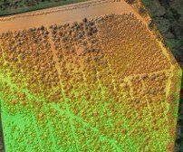
Terrain Modelling
Typical survey outcomes for LiDAR and/or Photogrammetry include Terrain, Surface and Canopy Height models, defined below.
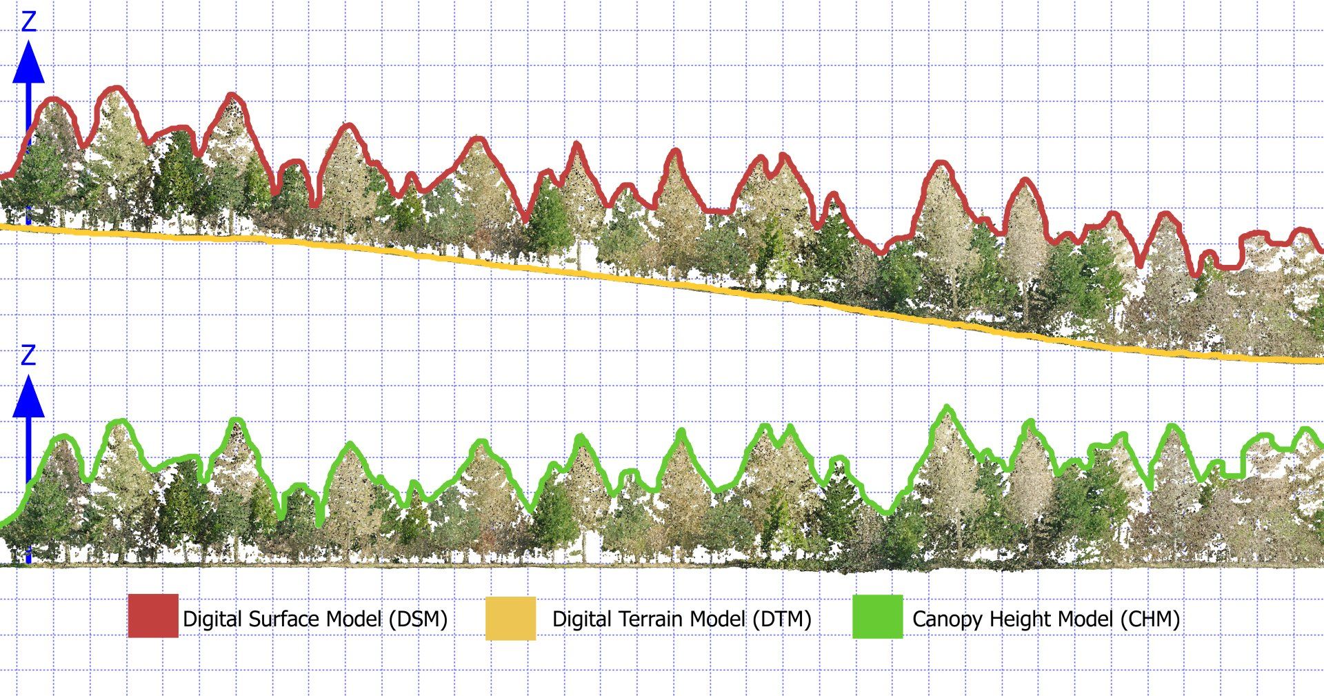
Digital Terrain Model (DTM)

Bare earth model elevation, excluding all non-ground points such as built (bridges, roads, towers) and natural (trees, vegetation).
Lidar
Land-use planning, infrastructural project management, soil science, hydrology and flow-direction studies
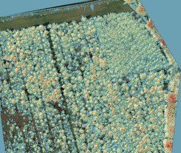
Digital Surface Model (DSM)
Capture of all natural and built features (including tree canopy, vegetation, buildings and powerlines).
Lidar or Photogrammetry
Urban planning, infrastructure inspection, aviation planning, vegetation management, visual line of site.
Canopy Height Model (CHM)
An extracted model taking the difference from DSM and DTM.
Lidar
Forestry Management.
The relationship between the models is best represented as follows:
LiDAR (Light Ranging & Detection)
LiDAR is pulsed light which bounces off the land or objects used to gain a range (distance). The known source position (using Inertial Measurement System and Global Positioning Systems) of the laser light pulse allows triangulation. Surveyed ground control markers and GPS base-stations are used to verify corrections including that for national grid. The aggregated light pulses create a very large point cloud of position and elevation values (XYZ). The greater the LiDAR source positioning, strength and frequency, the better the light penetration through tree canopy and vegetation and better outcome models (accuracy and reliability). LiDAR surveys are therefore particularly useful for all DTM, DSM and CHM. Paired imaging systems can enhance true view texture for more advanced visualisations.
Pros: Exceptional at obtaining high level of land coverage including penetration through trees and vegetation. (subject to Lidar strength and INS). Solution works in homogenous environments and varying light conditions and night.
Cons: More expensive solution / Weather: susceptible to fog and rain
Photogrammetry
Photogrammetry is the science of making measurements from photography. The process uses a process of triangulation but in respect to photo images (rather than points of light reflectance, as the LiDAR). The survey platform is therefore required to be from a known position, which is achieved using global positioning systems. The overlapping images are then stitched together using recognisable and similar markers, which can include surveyed-in ground control marker points. The ground control points are then used to support the corrections required to achieve a national grid based orthorectified mosaic (orthomosaic) combined image. The process can also be used to develop a point cloud (individual data points with xyz coordinates) which can be used to support generation of a DTM and a DSM vegetation permitting.
Pros: Relatively low cost solution in obtaining basic DSM mapping (subject to camera resolution, height of survey and ground control).
Cons: Weather and Light: Susceptible to rain, fog, wind and poor/highly variable light conditions / Homogenous Surface Areas: Low contrast and uniformly textured surfaces such as sand, water, short grass can provide difficulties in the software matching processes resulting in increased errors.
Survey Processes
The survey approach will always typically involve significant planning and preparation of the subject area to be surveyed. This will include assessment of the area to ensure that it is safe to fly and all necessary permissions are in place prior to any site work.
Survey teams (typically a pilot and a spotter) will base themselves in key positions to maintain Visual Line of Site (VLOS). The area of survey can be extending by moving the base or applying additional spotters for Extended Visual Line of Site (EVLOS). Larger areas, where VLOS and EVLOS are not possible, require a specific safety case for approvals for Beyond Visual Line of Site (BVLOS).
Although many drones are fitted with Real Time or Post Processing Kinetics (RTK/PPK - a process to enhance positioning using global navigational satellites in real time or post flight) it is best practice to ground truth all survey based data from drones. This is achieved using Ground Control Points (surveyed ground based marker positions) and with RTK base station(s). Ground Control Points are essential for supporting surveys which are to be repeated such as peatland restoration, mining or coastal surveys.
What survey method should I select?
The survey choice is not necessarily an either/or, but with advances in technology both methods can be applied, and at the same time. This offers the best of both worlds with far richer datasets. However, as a guide the core decision making factors include:
LiDAR
Mapping of difficult to access, complex and overgrown terrain
Capturing details on thin, vertical or man-made structures
Projects where details and precision are priority
Where detailed vegetation structural diversity and modelling is required
When there is low light or varying light conditions.
Photogrammetry
Context rich scanning which requires minimal post processing and expertise.
Datasets that need visual assessment.
What should I consider when procuring a survey?
Not all UAS Platforms, sensors and workflow are made equally. You could potentially achieve a survey using a low cost off-the-shelf drone and have some nice images but then no reliable usable data. Robust data is the foundation for all of your analysis, future monitoring and your evidence. Key things to consider are:
Objectives: What you wish to achieve (basic terrain, volumetric, biomass, modelling, analysis, structural, image)
Size: The size of an area will determine the survey method, height and sensor grades used.
Accuracy/Resolution: The greater the accuracy the larger the dataset, the lower the flight and the higher sensor rating. A photogrammetry survey could be achieved with a basic 20mp camera flying at 40m to achieve a <10cm RMSE or a 61mp camera flying at 80m to achieve a <2cm RMSE. A lidar survey can use a basic sensor (solid state) achieving 300,000pts/s through 8 channels at <40m and give <10cm RMSE or a higher end sensor at 1million pts/s across 32 channels at <80m to achieve <2.5cm RMSE. Be clear on what is required and don't over specify.
Analytics: Photogrammetry and low end lidar are usually not sufficient for more advanced assessment (volumetric temporal changes, vegetation structural analysis, biomass etc).
Timing: Lidar can be used any time of the day or evening, while photogrammetry is impacted by time of day. Quality useful images avoid shadowing effects which result from sun position and weather changes.
Data Size: The raw and processed datasets can increase in size dramatically when higher resolutions are specified. A typical outcome from a higher quality lidar and photogrammetry survey across 400ha will result in 4Tb of data.
Flight Management: Good surveys are fully compliant, well planned, insured, HSE conscious, involve engagement with land/property owners and take privacy seriously.
Further factors to consider are weather, land homogeneity, data sharing, environmental/ecological sensitivity, flight hazards and seasonality.
Applications
There are a range of applications where LiDAR and/or Photogrammetry can be applied. These can be enhanced when used with Multispectral, Thermal or SAR sensing. Sensing can be achieved at scale from a range of platforms.
| Application | Description | Use Cases |
|---|---|---|
| Land Mapping | Digital Surface Modelling (Image/lidar), digital terrain mapping (lidar) | Topographical |
| Vegetation Structure | Primarily lidar with photogrammetry to support key condition factors such as canopy height, leaf density, roughness, rugosity, light penetration etc | Forest, biodiversity net gain, habitat, land cover mapping |
| Biomass | Primarily lidar as some light penetrates through the vegetation cover providing useful data on the level of biomass for crops and forest. | Forest carbon/production, agricultural |
| Volumetric | Primarily lidar for penetrating vegetation to allow volume calculations and assess temporal changes in erosion, accretion or landfill/quarry/mining | Coastal monitoring, mining, earthworks |
| Modelling and Visualisation | Generation of 2d/3d models to support visualisation for engagement. TYpically used with games engine and immersive tools. | Stakeholder engagement |
| Habitat Mapping | Photogrammetry and lidar to support assessment of land-cover to support high level assessment of habitat classification. | Ecological, rewilding, agriculture |
| Feature Mapping | Primarily lidar, but usually paired with lidar to support identification and assessment of key features including fencing, walls, boundaries, water features, archaeological features or structures | Land managers, agricultural, rewilding, infrastructure |