
BS10: Stakeholder Engagement
Closed, operational or waste/materials handling typically requires much survey and monitoring. This has typically been undertaken using ground based techniques with mixed quality outcomes. Drones sensing and survey offers a cost effective solution to enhance coverage and accuracy, provide greater detail and to speed workflow.
Definition
The primary objectives for many environmental surveys may be technical in nature. However, the purpose of many projects is not just to analyse problems and determine solutions, but to communicate this to a range of stakeholders in an accessible, understandable and meaningful way.
Remote environmental survey outcomes will generate complex data in large volumes, with much of the assessment and analysis requiring powerful computers, cloud based processing and specialist (and normally expensive) software.
The majority of stakeholders (public, partners, client, regulators etc) are unlikely to have the specialist software or capacity to visualise or interact with the same data. It is therefore important to consider the whole project lifecycle and outcomes carefully to ensure the optimum benefit from the survey undertaken.
Key Considerations for Engagement
Ground Permissions
Undertaking a survey would normally operate based on obtaining the permission of the owner of the property. Surveys can involve large areas of land with multiple ownerships. The most common approach is notification and consultation, as appropriate. Key land owners can include the local authority, farmers and private residential.
Identification of land ownership can be achieved through the local authority or commercially via a geographical data supplier. Notifications should only be undertaken in respect to the Area of Interest and subject to the Flight Plan. Notification should include details of the survey sponsor, reason for the survey, survey contractor and dates as well as a right of reply.
It is normally good practice for the field surveyor to undertake an on site consultation to ensure access approval, gain additional confirmation for emergency landing areas or any permissions for hosting any survey equipment. A record of any exchanges between land owners, property owners and the public should be maintained.
Privacy
Privacy or personal data is an important consideration for any UAV survey where images of property and people may be collected through the nature of the survey, or inadvertently. The collection of such data will fall within the General Data Protection Regulations (GDPR) and is also considered within CAA Guidance (CAP722, 2020).
Pre-flight planning: Consideration is required to ensure the privacy of residents, people and personal property at pre-flight stage. This will allow the opportunity to (a) actively avoid or determine alternate survey methods, and (b) where privacy may be an issue, determine a solution to minimise any possible impact.
During Operations: Circumstances may change on site. The field operator is required to be vigilante to (a) avoid where possible any privacy related issues, and (b) be sensitive to local needs.
Data Processing: Any images inadvertently collected or otherwise that may be considered private (ie where an individual could be identified) then the image should be blurred or removed from the survey collection. If any private property owner has expressly refused permission, then the images relating to the property will be removed prior to processing or publishing.
While privacy and protection issues are normally related to photography images, local residents or people on or adjacent to the survey area may not be in a position to determine if a drone is installed with a photography camera or a lidar or spectral survey sensor. The site operator should be sensitive to on site requests and where possible communicate the nature and purpose of the survey being undertaken.
A number of signs (drone survey in progress) with a contact phone number should be placed at key access locations.
Drones for Good
The use of drones for survey related tasks is an evolving field. It is important to continue to demonstrate and showcase the benefits of drone survey work to ensure continued good feedback for achieving required ground permissions and overcoming any concerns in respect to privacy.
If the survey involves common ground, community related issues or private land/property then involving the public in the process, including showcasing the outcomes, is a key consideration for the project sponsor. This is even more important if multiple surveys are required or where land/property may be impacted (as shown in survey outcomes).
Client Groups and Contractors
Although a client may sponsor the procurement of a survey, the outcomes are often required to allow contractors or consultants the data to achieve their own workflow. It is therefore important that the data outcomes are in a suitable format to allow it to be used by the range of parties for their own specific tasks.
Most projects will have a common set of data standards set up/agreed at the start of a project to ensure that the data outcomes can be supplied in appropriate formats. The project initiation is also a good opportunity to determine all the relevant parties who will use the data as well as how the data will be used.
It is also possible that some of these associated stakeholders will not have the software/hardware to manage the data. In these cases, specific solutions may be required.
Consultation
Consultation can include the dissemination of the survey data outcomes to a wider group. This can include a specific stakeholder engagement group of government agencies/authorities or the public. Consultation can occur where the data shows a potential impact, is sensitive or is part of a regulatory process (such as planning). In most cases, it is normal to assume that the groups or individuals will not have the software/hardware or necessarily the skills to manage the survey outcome data.
Consultation processes will often be considered as a project/campaign and managed by skilled individuals in consultation processes. The consultation process may vary from a basic factual representation through to a highly visualised interactive content.
Project Example - Consultation Process
The following shows the typical consultation considerations during an environmental survey project.

Possible Consultation Tools/ Routes
Consultation requires a distillation and curation of the survey outcome data to a common level that is readily accessible and in a form that is understandable. The content of which should be curated in a form to illustrate a point and a response.
There are a range of possible options available, including:
Basic Factual Data
This is where the key factual elements are extracted from the assessment of the survey data and simply expressed in a presentation (e.g. Microsoft PowerPoint). This can include generated images to provide some visual content.
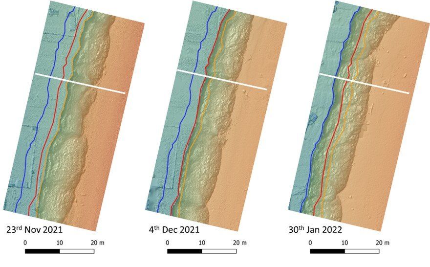
Example: Extracted digital terrain models of a coastal segment from different surveys to demonstrate the process of coastal erosion.
Video
The use of more interactive or engaging media is an option. In a similar mechanism with using power point, data and images can be presented in a video outcome. The video can then be published via a website or platform, such as youtube.
Visually Interactive
The above options only allow the dissemination of the summary or factual data outcomes rather than survey data. Where there is a requirement to fully use the actual survey data then there are a number of options available.
GIS Systems: The data can be provided in common accessible GIS systems (e.g. QGIS, ESRI) which can be made available to the public. However, these rely on some level of knowledge for use and may require the sponsor/host in obtaining a specific licence. The data can be provided in a 2d map style format, but provide some level of interaction or exploration.
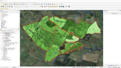
Example: GIS enabled for multi access sharing with survey data outcomes
Games Engine: Games engine (unity, unreal etc) provides a software agnostic solution for presenting and showcasing large volumes of landscape data in an accessible and interactive form. The use of occlusion and specialised graphics management can allow full 3d models of survey data outcomes whilst allowing the user to navigate through or around the model. Further, the model can be enhanced or modified to overlay additional data or show changes in time.
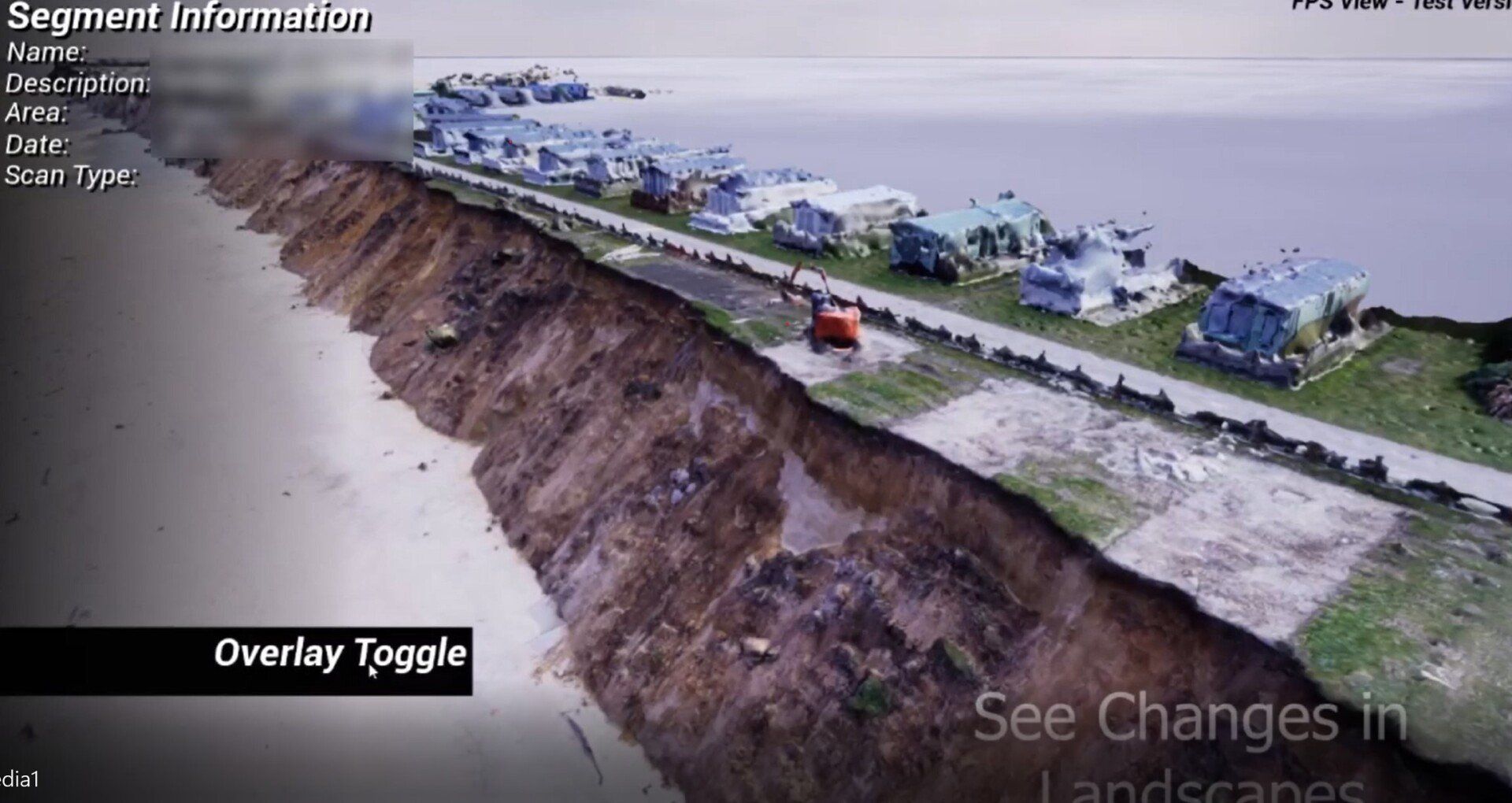
Example of survey data output as a 3d interactive 3d model using games engine technology.
Application
Surveyar have developed a workflow solution to support a range of highly visual and interactive options to suit the project needs and requirements for stakeholder engagement and consultation. These are built around accessibility and interaction.
The use of these systems can be readily and cost effectively integrated into any remote environmental survey project to enhance overall project outcomes.
See Also