
BS11: Climate Change Impact
We have and we are building the tools to support you in measuring your climate change impact. We wish to use best available leading edge science to provide robust data to ensure optimised actionable decisions.
Definition
Climate change is a significant issue with a drive to reducing any greenhouse gas through emission reduction and the development of carbon sinks, with a goal of being net zero by 2050. This is quite a challenge, the targets of which cannot be adequately assessed without reliable robust and defensible measurement.
Many organisations, local authorities and land owners/managers now have a requirement to assess the climate change impact from their projects or from any changes to the land. The legislative and guidance requirements vary by sector but include government GHG inventory (update, refine and understand land and land use emissions), carbon code (process for establishing carbon credits in forestry and peatland etc), in agriculture (ELMS, Sustainable farming initiative) and in corporate financial and project accounting (ISO 14064, PAS2060 etc).
Considerable reliance has been placed on using established GHG emission inventory as a broad starting point for creating proxy values on which to support modelling of emissions and sinks from land use change. There are currently very few circumstances where GHG net changes are actually measured. The use and reliance in models based on broad based GHG inventory data has led to many cases of ‘greenwashing’ or complaints of ‘massaging the models’ where the modelled results show perhaps overly optimistic expectations of reduced emissions or increase sequestration.
However, until recently there have been no viable solutions to support independent verification / validation.

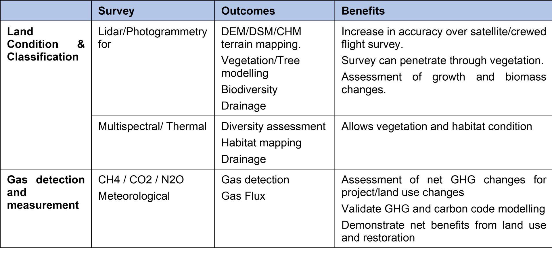
Typical Survey & Assessment
Surveys can include an assessment of the land and features relating to the catchment and its drainage, the nature and condition of the water course/drains/coastal waters/storage or the atmospheric exchanges.
Baseline and Monitoring Land Condition Assessment
A baseline survey establishes the initial condition of the land from which changes can be monitored with time. Both are important in understanding how change can be related to GHG emissions and sequestration. Understanding the relationship can also be useful in optimising how land is used to achieve optimal outcomes.
Traditional surveys will use proxy based GHG inventory data with satellite based sensing data and/or sampled land survey data. The application of proxy based data can often mask nuances in heterogenous land conditions, but have been sufficient, to date, to provide a broad basis for determining climate change impacts/benefits.
The use of remote sensing with drones offers the potential for greater level of detail, accuracy and reliability with a full coverage. This in itself can be used with GHG proxy data, or net GHG gas exchange measurements can be undertaken (see below).
A drone based survey can be used to examine the land topography, vegetation/biomass and soil/vegetation condition and subsequent changes with time (e.g. tree growth, peatland restoration, farming changes). Drone based surveys will typically be undertaken using lidar, photography and multispectral sensing.
Land use and land use change surveys are typically required for project planning, forestry management, peatland restoration and agricultural land uses in support of compliance, grants/funding and biodiversity requirements. The data from drone based surveys can be used to meet these requirements while also supporting climate change impact assessment.
Net Greenhouse Gas Exchange Assessment
Measuring net carbon or greenhouse gas changes can replace or verify proxy based GHG data for the specific project or land use change requiring assessment. The key benefits in obtaining actual site measurements:
- The production of defensible data to support validation of modelled data.
- Obtain data of the overall net GHG changes, resulting from the specific land/site and change mechanisms.
- Obtain data in different seasons and with time to demonstrate how the GHG changes with land use change
- Data that is specific to the land condition survey, allowing useful correlation
The most reliable method of measuring gas fluxes for net GHG exchange is by using flux towers. However, these are typically very expensive and are permanent installations rendering them commercially unsuitable for most projects.
Drone platforms (rotary, fixed wing) with gas and meteorological sensors can be used independently or in conjunction with ground-based measurements can be used with advanced science modelling to calculate the net changes and impacts of land used emissions in the atmosphere.
How can Drone Surveys Help
Drone surveys can help by first establishing the condition of the land to allow monitoring of land use changes. By measuring net GHG exchanges we can determine the impact or the benefit of these changes allowing us to learn/adapt and optimise land use changes to greatest benefit.
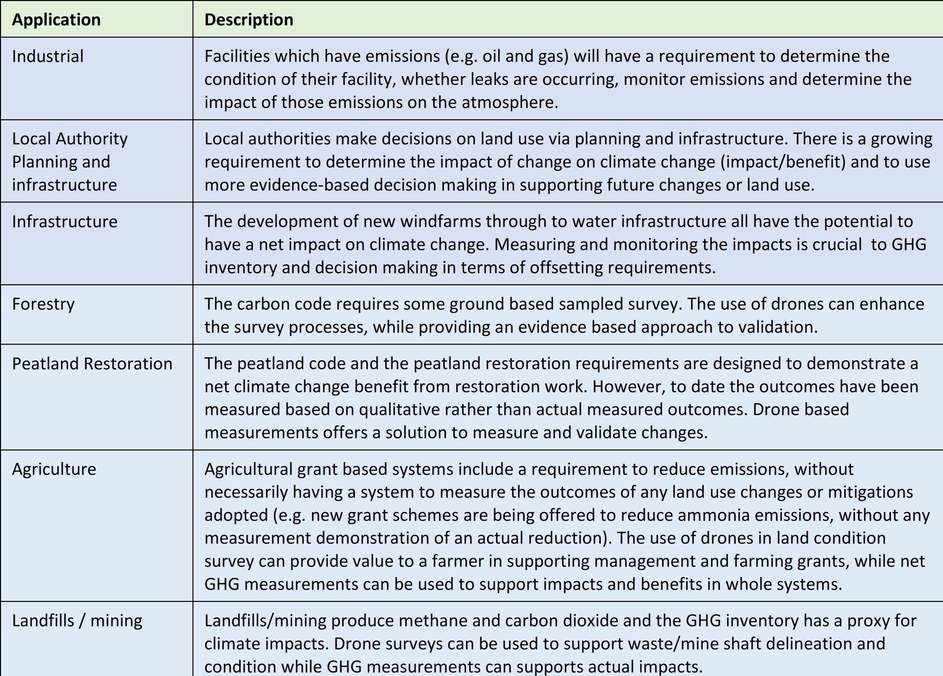
Applications
There are a number of applications relating to climate change impact assessment. Notwithstanding regulatory, these include:
Survey Benefits, Issues and Considerations
The following re-iterates some of the common issues that surveyors are faced with and which should be considered when selecting an appropriate survey method.
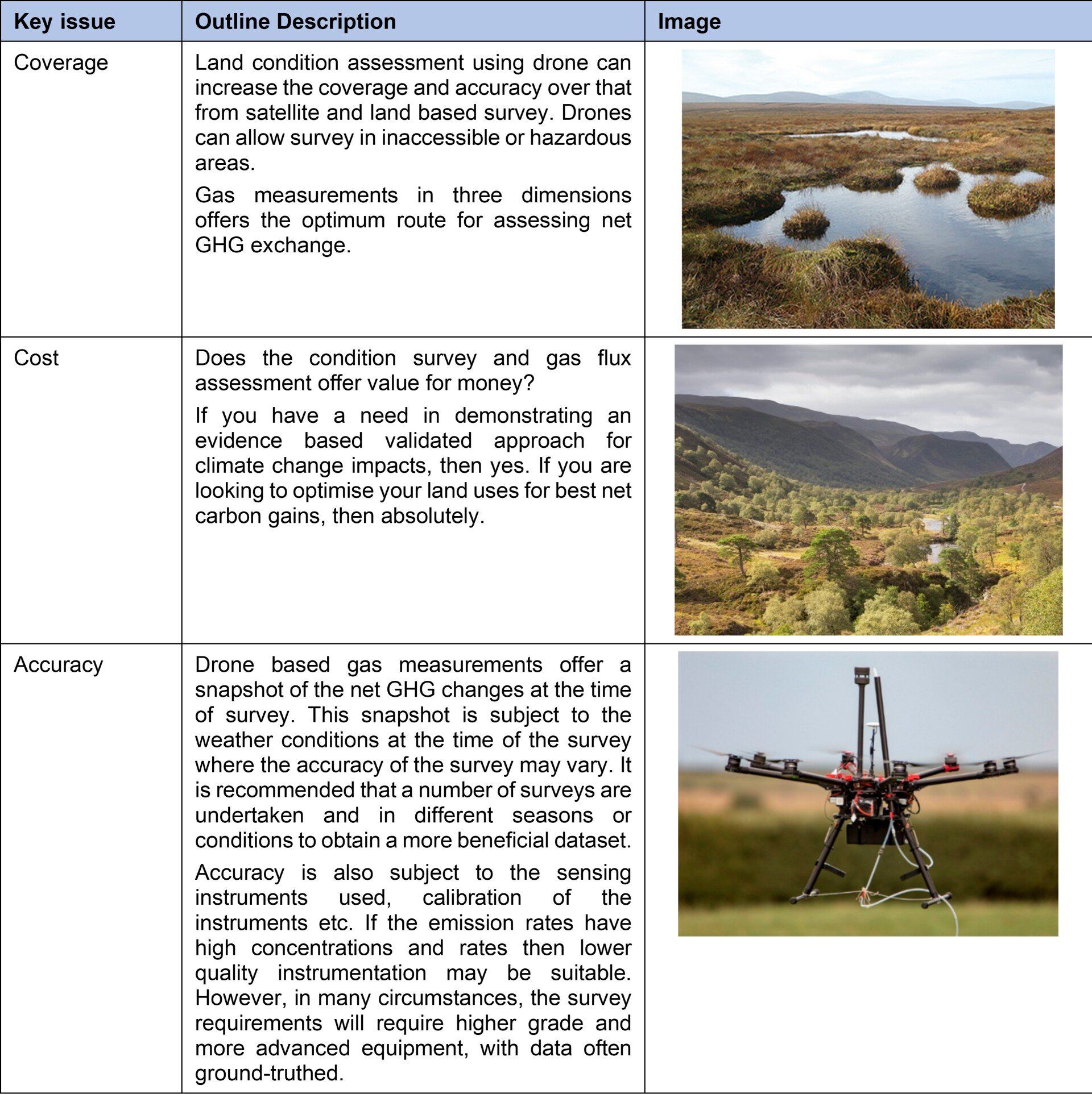
Drone based platforms are not infallible and have some limitations. These can include restricted flight areas and poor weather conditions. In many survey cases, it is useful to consider drones along with a number of survey tools from satellite data through to ground based survey.
Examples
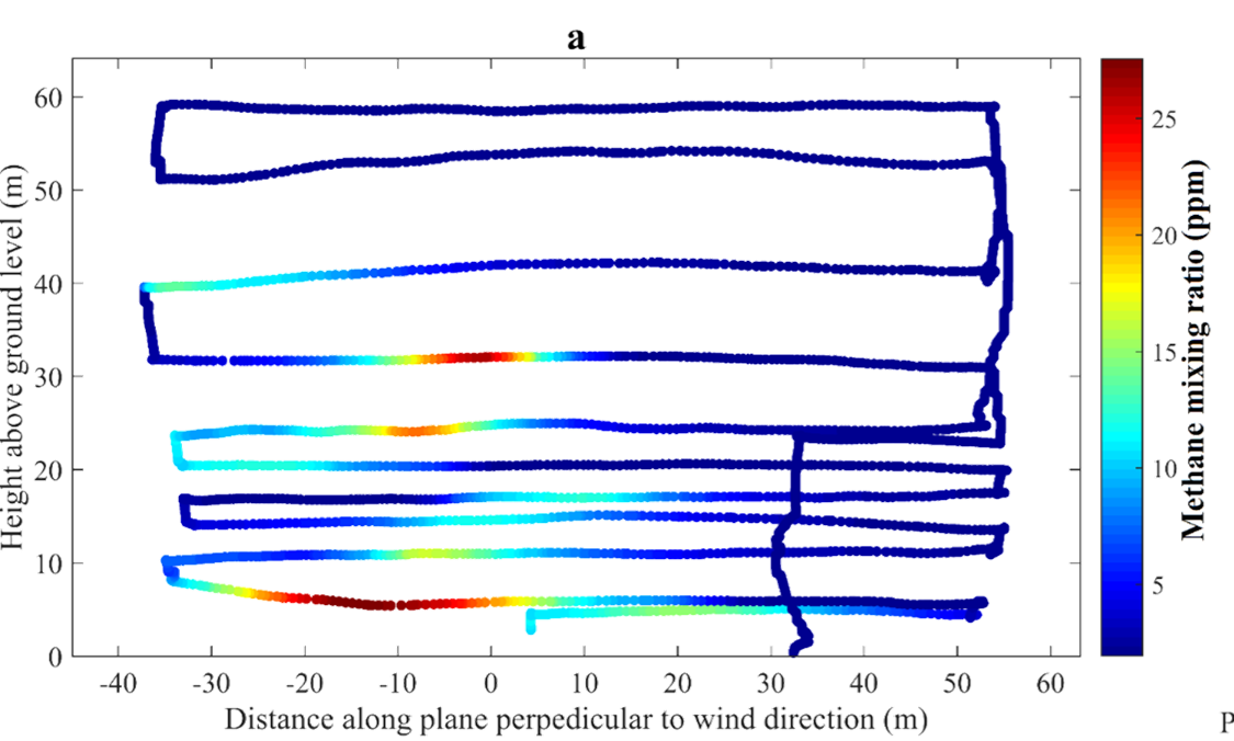
Example: Methane measurement plot across a closed landfill site
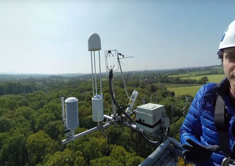
Example: Setting up and testing data from a ground based gas and meteorological station for gas flux measurements within a forest environment.
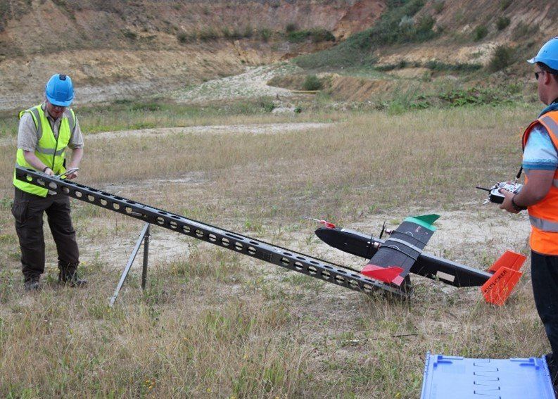
Example: Using a fixed wing drone platform to obtain gas detection measurements from a closed landfill site in the midlands.
See Also