
BS03: Ecology and Biodiversity
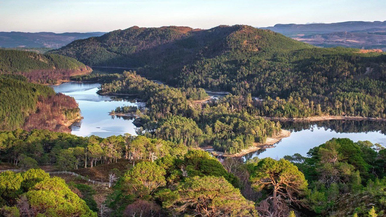
The saying goes that 'you can't see the wood for the trees'. An array of new sensor technologies working with drone platforms can support ecologists with greater coverage and accuracy, vegetation penetration and assessment of condition and disease. These technologies and innovations can provide richer and more reliable data while making monitoring and assessment of impacts much easier.
Definition
Ecology is the branch of science concerned with the relations of organisms to one another and to their physical surroundings. Habitat assessment is concerned with the physical features of an environment (topography, plant types, climate, water quality, soil conditions etc). Habitat survey, monitoring and classification form part of Habitat Management Plans. Habitat Management Plans are typically required relating to any development planning, country stewardship/land management and wildlife development and are intended as a guide for land managers to facilitate works that will result in the maintenance of, or increase in, the biodiversity value of retained and/or newly created habitats, or indeed of the protection of species.
Typical Survey & Assessment
Surveys can include an assessment of the land and features relating to the catchment and its drainage, the nature and condition of the water course/drains/coastal waters/storage or the atmospheric exchanges.
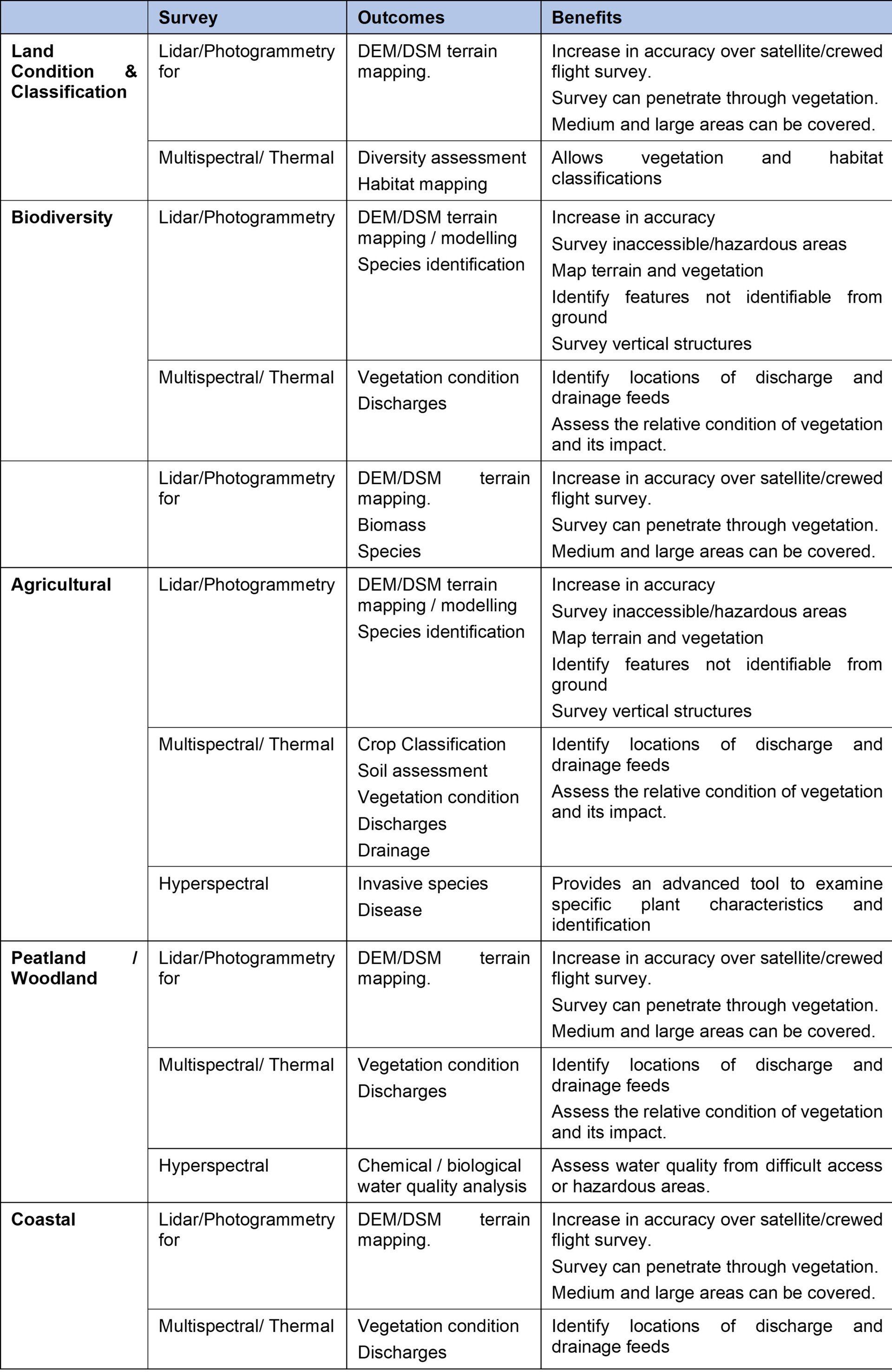
Land Condition Assessment & Classification
Determining the condition of the physical and biological properties of the land helps us classify and group habitats. Much work has already been undertaken in the assessment of these habitats primarily using satellite and historical mapping data. While such data is useful, it has reasonably low levels of resolution and is not always up-to-date. However, the interpreted data is likely sufficient to support regional habitat assessments, but may not be particularly detailed enough to support robust and evidenced based habitat management for specific projects, nor sufficient to support monitoring or performance objectives for project outcomes.
Habitat assessment will typically include an evaluation of topography, land characteristics, drainage, vegetation types, climate conditions, water quality and geology/soil conditions. These features support ecologists in assessing and classifying habitats by group, type and sub-types. Initial surveys are often used as a baseline to support decision making for habitat management and development planning, the outcomes of which are quite often monitored in post action surveys.
Surveys can be undertaken in respect both to systems that are designed to be natural (e.g. forests, agricultural, peatland, marine and parks) and to the built environment (e.g. infrastructure, housing, energy). The management plans for the latter will also form part of an environmental impact assessment.
The Habitats Regulations require competent authorities to consider whether any plan or project may have a likely significant effect on a protected habitat site by undertaking a Habitats Regulations Appraisal. These typically require a baseline assessment, an impact assessment and monitoring to demonstrate net changes.
Biodiversity
Biodiversity assessment examines the variety of plant and animal life in a particular habitat. While this is a component of habitat management, it is a growing metric to support the monitoring of habitats and their improvements. Biodiversity assessment is now a requirement of development planning, where for many projects, net gain must be demonstrated.
DEFRA and Natural England have produced a biodiversity calculation tool (version 3.0) which provides a common mechanism to allow consultants and land managers to calculate a biodiversity score for each of the respective habitat areas within their management. The metrics are a mixture or qualitative and quantitative responses based on observation or survey using sample areas (which many vary between habitats).
Agriculture
The Sustainable Farming Incentive (SFI) is the updated farm payments incentive scheme linked to sustainable farming practices, which includes elements of habitat, natural capital and biodiversity requirements, which if met, unlock subsidy related payments. The current requirements relate mainly to the soil condition for agriculture, but also consider some sustainable farming and habitat condition factors. The process is based on self-assessment, but will include an audit and monitoring requirement. Implementation is from 2022 [Sustainable Farming Incentive: how the scheme will work in 2022 - GOV.UK (www.gov.uk)].
In Scotland, the payment requirement for farmers is managed through a requirement to complete a Farm Environmental Assessment, which will typically include a requirement to produce a Farm Environment Map (habitats, water features and hedgerows etc), Farm Management Map, Field Map and complete a Diffuse Pollution Assessment.
Farmers are also encouraged to use evidence based indicators to show biodiversity and net improvements.
Woodland Condition Assessment
The DEFRA and the Scottish Government schemes extend into woodland conditions. These schemes are linked to agricultural payments aligned with SFI and rural grants respectively. The requirement for farmers (and foresters) is to complete a woodland condition assessment. The woodland condition assessment is almost equivalent to the DEFRA biodiversity metrics for habitat assessment, following similar methods of survey approach (typically land based and observation). They include factors such as age distribution, herbivore impact, invasive species, occupancy, tree health and vegetation etc.
Woodland can also be subject to a different set of survey requirements if they are included within the woodland carbon code scheme for carbon offsetting and trading. There are survey requirements set out by the Woodland Carbon Code (Template Documents - UK Woodland Carbon Code) which include baseline survey, monitoring and requirement for validation. The survey metrics vary slightly from the woodland condition assessment with a requirement to include % of specific species and their spacings, and age along with data on establishment and initial soil condition.
Peatland
The DEFRA biodiversity calculation tool includes ‘wetland habitat’, which incorporates blanket bog and lowland raised bog within its definition. This could potentially be applied to peatland areas.
However, the Peatland Condition Assessment (Naturescot) sets out the requirements for assessing the condition of peatland habitats with the purpose of informing changes in management and restoration to improve condition. While this is not a component of the rural grants or SFI schemes, it is a condition of grant related payments in respect to peatland restoration. The metrics include assessment of sphagnum cover, damage (natural, burning, trampling etc), drainage and peat loss. Survey methods are traditionally based on sampling areas, are ground based and are a combination of qualitative and quantitative.
If the peatland is eligible through survey demonstration then it may be suitable for the purposes of carbon offsetting through following the requirements of the Peatland Code (Peatland Code | IUCN UK Peatland Programme (iucn-uk-peatlandprogramme.org)). The peatland code requires a baseline survey (prior to any restoration) and a monitoring programme to demonstrate change. The survey requirements are broadly similar to that of the Peatland Condition Assessment (but do have some variances including the outcomes are generally more quantitative). However, the Peatland Condition Assessment and Peatland Code Assessment could be aligned.
Coastal / Lake Habitat
Habitat surveys also include assessment of coastal areas and lakes (intertidal areas, lakes and ponds) where the emphasis on phase 1 habitat survey and biodiversity survey is on coastal processes, invasive species, water quality, litter, non-natural structures and vegetation colonisation.
Animals
Although the habitat and biodiversity requirements highlighted above are focussed on habitats and natural conditions, there is an evolving component which a requirement to identify animals (with a focus on protected species and diversity). The phase 2 habitat survey does include a component that assesses animal species and communities, and may be triggered if the phase 1 identifies the possibility of protected species (e.g. bats).
Meteorological
The assessment of meteorological conditions, within a habitat area, is typically based on available data from the Met Office (which will cover areas where ground based measurement equipment is available). The data is used to support modelling and predictions of habitat changes and species sustainability.
Hydrology & Water Quality
The quality of water within a catchment, river or coastal environment is important in understanding ecology/biodiversity and pollution impacts (industrial, farming, waste water). Environmental agencies will have a requirement to monitor the chemical and biological condition of main water bodies (reservoirs, rivers and coastal areas) and to determine quality classification. This is used to support environmental compliance as well as to support plans and measures for water quality improvements, in line with the Water Framework Directive.
There are many point and diffuse pollutant sources arising from run-off, drainage, industrial discharge and waste/foul water from farming, industry, water treatment and urban land. The responsibility to manage these rests with the environment agency, including the permitting and management of discharges from industry and waste water treatment. This in most cases places an obligation on the ‘polluter’ to monitor and assess their own emissions into the water environment.
The quality of the water is critical to habitat, ecosystems and human health.
Drainage Assessment
Drainage assessment is also important in agriculture and rural land use systems to support the optimisation of crop growth. Farming based drainage systems will include field drainage and field ditches, normally used to prevent any water accumulation within fields. Drainage systems were also applied to peatland areas in attempts to drain the land and make it suitable for farming purposes. However, this also harms the peat systems which are considered an important carbon store to help mitigate climate change. In peatlands, restoration will involve the identification and removal of drainage networks to support conditions for the peatland to continue its growth in bog type conditions.
Drainage assessments are also required in a range of other application areas including forestry, sustainable/habitat restoration and hydropower management.
How can Drone Surveys Help
Regional habitat mapping is typically undertaken using satellite data and ground truthed using more locally based surveys, traditionally ground based. However, the use of drones as platforms for survey is becoming more prevalent, given the improvements in survey coverage and level of accuracy.
The majority of habitat and biodiversity surveys are undertaken using ground based methods using a combination of qualitative and quantitative metrics. Surveys tend to be based on selecting sample areas as representative indicators of larger areas and to allow assessments to be undertaken as efficiently as they can, given the extent of cover for some habitat or project areas.
Drones with various sensors can offer a route to enhance these existing surveys by allowing the survey cover of a whole habitat or project area, by providing technology to give better insights, allowing automation of assessment of larger survey areas and better sampling of representative areas to ground truth and obtain qualitative metrics.
Drones can offer a solution to enhance baseline assessment as well as monitoring changes and provide a robust evidence basis for making specific and locally based interventions and actions or assessment of performance.
Many habitats are difficult to access with potentially hazardous areas making ground based survey and survey of required sample areas difficult. Drones provide a solution to ensure that the entire habitat or project area can be assessed.
Survey Benefits, Issues and Considerations
The following re-iterates some of the common issues that surveyors are faced with and which should be considered when selecting an appropriate survey method.
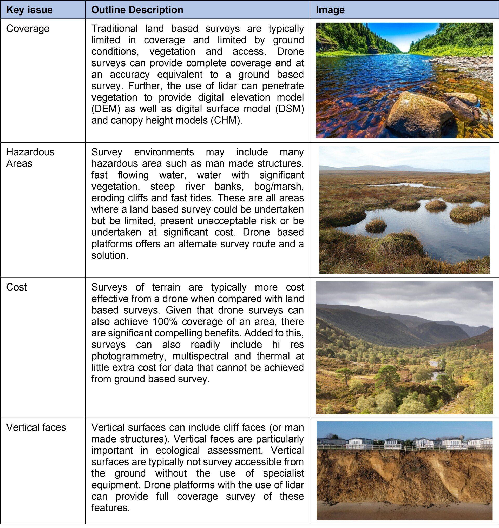
Drone based platforms are not infallible and have some limitations. These can include restricted flight areas and poor weather conditions. In many survey cases, it is useful to consider drones along with a number of survey tools from satellite data through to ground based survey.
Examples
Example: Survey of a forest near Birmingham with DSM, DEM and CHM
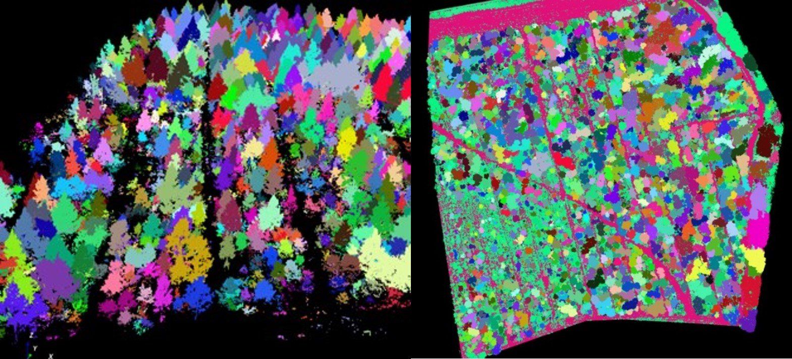
Example: Forest survey showing tree segmentations
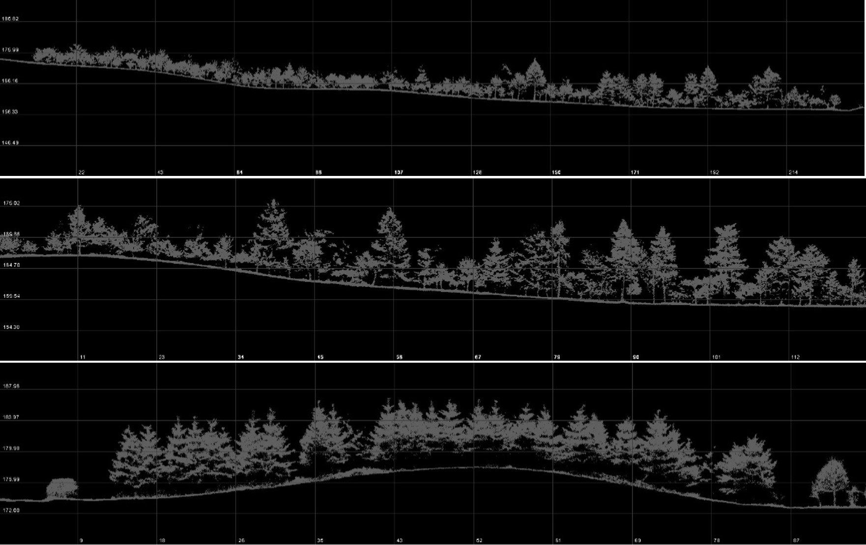
Example: Lidar surveys of forested areas, generated sections from various types of forested areas.
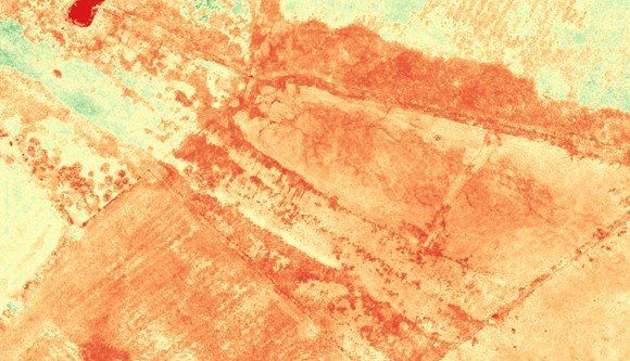
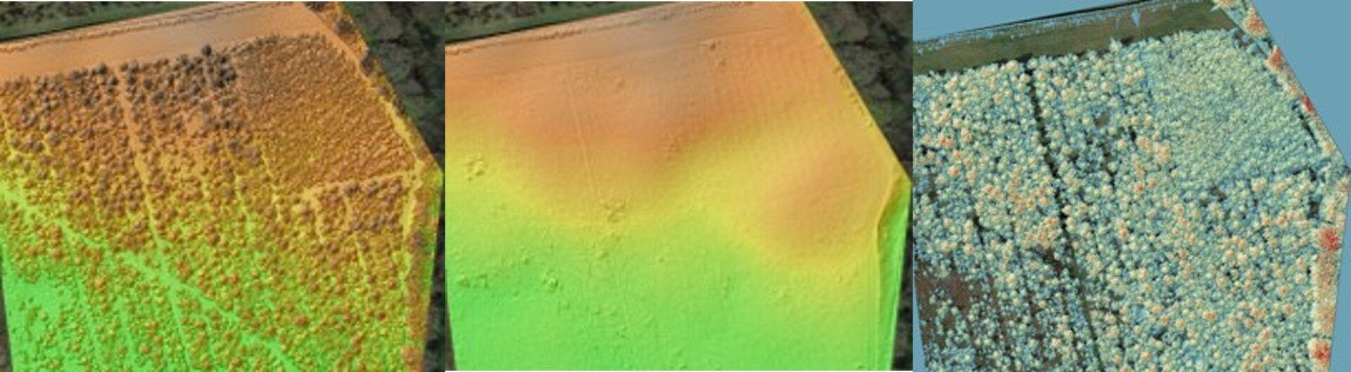
Example: Use of multispectral survey (OSAVI) to support drainage assessment at an agricultural site.
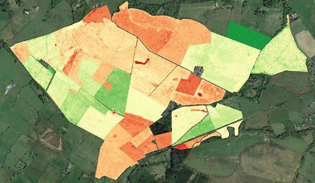
Example: Use of multispectral survey (NIRV) to support habitat classification and condition
See Also