FS07: Geophysics
Geophysics is a developing tool with drones. Multiple sensing solutions are being developed and then applied in both traditional and new ways providing a unique and innovative approach to areas that are inaccessible to ground based solutions.
Background
Geophysics is the natural science concerned with physical processes and properties of the earth and its surrounding environment, and the use of quantitative methods for their analysis.
There is a growing evolution of sensor technologies that have either only been used in traditional ground based surveys or which have been used with traditional non-destructive testing that are now offering potential opportunities for new measurements and assessment with drones. Drones overcome many of the land and property access based restrictions allowing new possibilities in measurement. The field is new and expanding quickly as methods are tested and demonstrated to be useful, reliable and cost effective.
Magnetometer
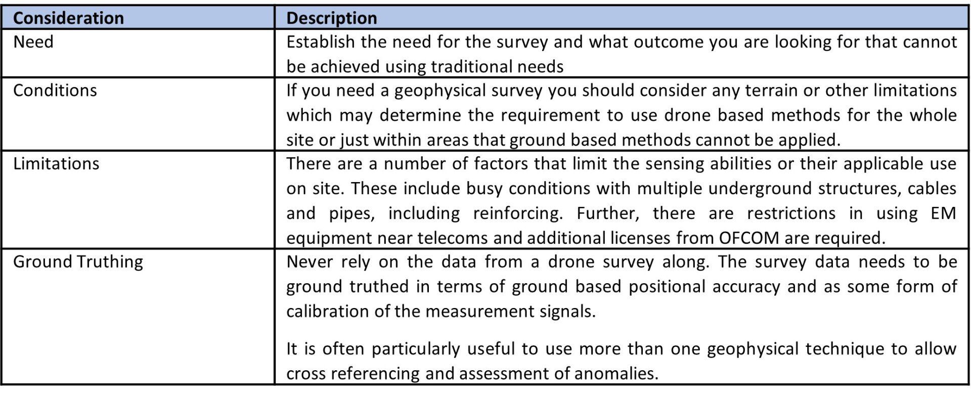
A magnetometer is a device that measures magnetic field. Traditionally, these surveys have been undertaken by ground based teams, who would drag a sensor sled along the ground, or through the use of fixed wing planes with large powerful sensors. While fixed wing survey solutions provide good coverage, the data is typical of low resolution and the projects and equipment are very expensive. Ground based survey solutions are accurate, reasonably reliable and cost effective but are best suited to accessible areas with reasonable ground conditions.
Drones equipped with magnetometer sensors represent a large technological leap for remote geophysical surveys. Sensor technology has reduced the weight of the sensors allowing them to be used on a drone platform. Technologies such as true terrain following can be applied to flight management to allow low flight conditions required for survey.
Equipment
Magnetometer equipment will measure (nano teslas) the total strength and direction of the magnetic field. The closer the sensor is to the ground the better the response. The surveys can be ground truthed using surveyed in ground based measurements. Examples of equipment include the Sensys Magdrone R3/R4, Geometric MagArrow and the GEM Systems GSMP35U.
Magdrone
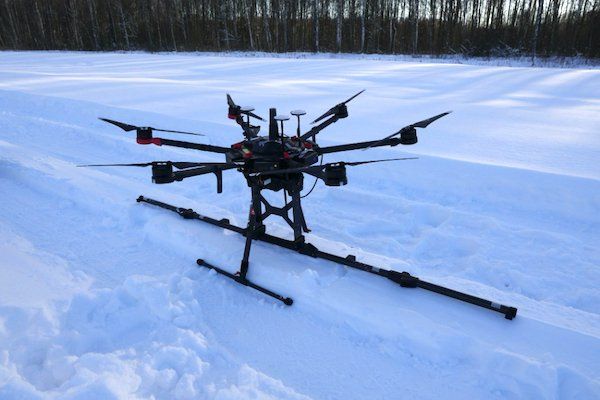
Results from Magdrone
Application
Most natural soils orientate their magnetic field with the magnetic poles. However, when the soil or rock is disturbed, the orientation is broken. Measuring magnetic fields can help us identify where the ground has been disturbed, where there are voids or where man-made or metal objects have been introduced into the ground (pipelines).
The survey process can be particularly useful for delineating areas of made ground, underground structures, pipelines, underground voids or unexploded ordnance. Magnetometer surveys have also been used to aid mineral surveys. These applications could be of use and benefit to geotechnical, archaeology, environmental and engineering consultants and specialists in land development.
Ground Probing Radar
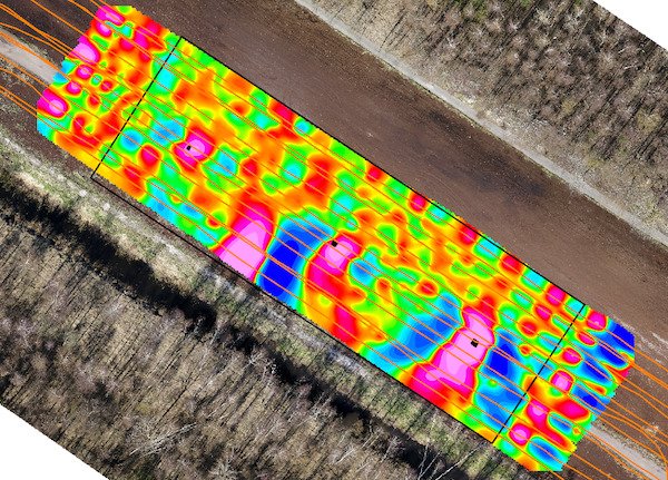
Ground probing radar is a geophysical method that uses radar pulses to image the subsurface. The pulses are electromagnetic radiation in the microwave band (typically 20MHz to 1400MHz) of the radio spectrum with a sensor to detect reflected returns. Sensors are set with different frequency ranges and bandwidths offering different strengths of signal and return measurement for different prospective ground conditions.
Traditional survey methods use a bogey or trolley which is pushed or dragged along the ground surface. Surveys are also possible using crewed flight. However, as in the magnetometer, the crewed flight based systems have a low accuracy as a consequence of the height and are particularly expensive yet provide a generic background coverage. The ground based systems provide the most accurate coverage but have limitations in difficult or uneven ground conditions. All measurements from any method are impacted by moisture, large metal objects (including reinforced concrete) or underground electrical cables. Surveys are also typically limited to areas where there are no sensitive telecommunication equipment and interference may result.
New evolution in technologies has allowed sensor technology to become lighter and much more flexible. The sensors can now be used with drone platforms. The advent of low altitude true terrain following allows flight at 5 to 10m above ground level that is required to obtain the optimum ground based measurements.
Equipment
GPR sensors for drones are currently developed by Radar Systems (Zonde -12e) and Radarteam (CBD, Cobra). Surveys can be ground truthed using ground control points and ground based measurements. The systems also require calibration.
Application
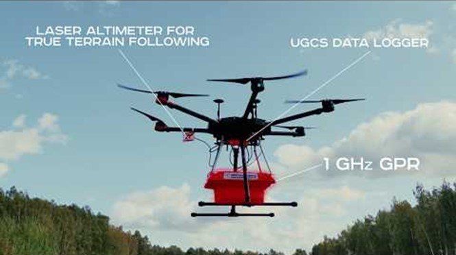
GPR surveys can measure slight relative variations in subsurface ground conditions as a consequence of different types of soil or materials absorbing or reflecting electromagnetic radiation. The greater the spectrum range monitored, the greater the potential for determining small variations as well as noise. Surveys are particularly useful for determining changes in geological structure at depths up to 10m below ground level. While boreholes are very accurate at the specific point of survey, the level of coverage can be extended quickly through the use of GPR.
Use case applications can include examining changes in geological condition across a development site, establishing rockhead levels and finding buried objects or structures. GPR can also be used for bathymetry applications for freshwater water bodies and supporting relative sediment depths. There are also possibilities for determining water table levels (although testing applicability is still being examined).
GPR Sensor
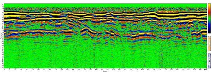
Results from GPR Survey
Considerations when selecting survey
Geophysical surveys are generally complicated and require the use of advanced software to support analysis and interpretation. Key considerations when selecting a survey are: