
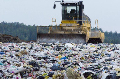
BS07: Waste Management
Closed, operational or waste/materials handling typically requires much survey and monitoring. This has typically been undertaken using ground based techniques with mixed quality outcomes. Drone sensing and survey offer a cost effective solution to enhance coverage and accuracy, provide greater detail and to speed workflow.
Definition
The condition and delineation of waste is important in the management of closed and operational landfills and during materials management in construction projects. This includes the assessment of coverage, volume, condition and available capacity measured with time to support decisions on environmental licensing, management and placement.
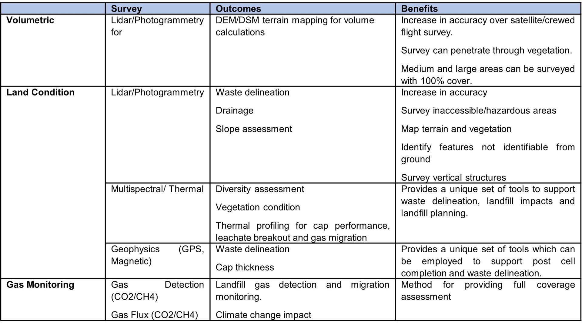
Typical Surveys and Assessments
Typical assessments can include volumetric surveys using photogrammetry and lidar. More advanced surveys will include multispectral, thermal, geophysics and gas detection
Operational Landfill
The demonstration of the extent and condition of a landfill is a typical waste licensing condition. The evidence based of which is typically used to surrender a license. However, there are also many older un-licensed closed landfill sites managed by local authorities for which there is little available data. In some cases monitoring arrangements may be insufficient or sub-optimal.
Assessment of the extent and condition of closed landfill sites is traditionally undertaken using historical mapping, available satellite lidar and ground based survey processes. These surveys may provide sufficient data to determine the likely extent of a closed landfill and to allow planning or modification of environmental management and monitoring. However, in many cases, the data is limited and initial ground based investigations can be unfocussed and costly.
Drone based topographical survey can include lidar and photogrammetry to provide 100% survey coverage of the subject site (and buffer areas). The lidar survey can penetrate through vegetation providing a full DEM terrain model of a site, which can be used to support assessment of the aerial extent of the landfill, but also used to support estimation of waste volume (when used with available crewed plane/satellite lidar).
The surveys can be extended to use radiometric thermal survey processes. Depending on the nature of any landfill capping, this can support assessment not only of delineation, but reveal possible enhanced landfill bacterial activity and possible leachate and landfill gas emissions. Such surveys are undertaken at dawn when there is the greatest possible contrast between background temperatures and heat generated.
The use of multispectral sensing can also be applied to identify areas of the site with poor or impacted vegetation or indeed areas of drainage/leachate breakout. These will support assessment of the extent and behaviour of the landfill.
Drones can be used with advanced gas detection which can be used to support a full coverage assessment of landfill gas ‘leakage’ and migration from the landfill. Further, more detailed assessment could also be applied to measure gas flux from the landfill and climate impacts.
Drones can also support geophysical survey (including magnetic and ground probing radar) which could be used to provide non-intrusive assessment of difficult terrain areas to support assessment of cap and waste thickness, as well as identification of any larger below ground objects.
The objective of drone based survey is to provide a rapid and cost effective solution that can support and optimise any ground based activity (e.g. permeant monitoring locations, gas/leachate mitigation).
Closed Landfill
Waste management licensing conditions and management requirements for operational landfills will require regular monitoring of waste volumes and available waste capacity as well as environmental monitoring for gas and leachate.
Traditional survey methods for volume calculations are undertaken using total survey stations with GPS to measure changes in cell volumes. Traditional survey for landfill gas includes obtaining measurements from drilled boreholes within and on the periphery of a landfill. These processes are generally adequate for regulatory and operational management requirements.
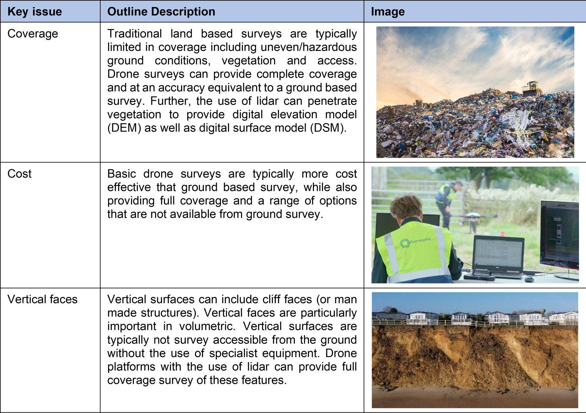
However, there will be some circumstances where the volume calculations are more complex, where uneven/hazardous conditions limit survey coverage or where greater level of detail is required in contested or due diligence requirements. This is when a drone with lidar/photogrammetry sensors can be of significant benefit and used to provide full coverage, dense and accurate survey of the subject site.
Further drone surveys using thermal and multispectral could be used to support assessment of performance of waste operations including cap integrity and any vegetation planting.
Gas detection using drones could also be used to assess landfill gas generation and migration with wider overall site (and surrounding area) coverage to complete any monitoring gaps and in demonstration of compliance. Gas flux analysis could also be applied with drones to show climate change impact.
Construction Materials Management Plans
Construction materials management plans are typically required with earthwork and remedial projects where soils/waste/materials are moved on/off site or reused on site. Such plans are typically required with planning, remedial plans or waste management exemption plans to demonstrate changes to materials on site.
Traditional survey methods use ground based GPS station systems where points are surveyed at various intervals to support the development of a contour plan. This is useful and accurate for most MMPs and their compliance. However, for more complex sites (larger areas, more complex waste handling, planning purposes and areas of uneven ground) a greater level of coverage is typically required. This can be achieved through drone based lidar and/or photogrammetry which can provide full coverage and where accurate volumes can be calculated quickly. The drones surveys can also be used to support monitoring of materials management within a site, the results used to support optimal materials management and regulatory compliance.
How can Drone Surveys Help
Drone survey platforms with sensors such as lidar, photogrammetry, multispectral, thermal, gas and geophysics can be used to provide greater survey coverage and provide insights that are not available from ground based survey, at a cost equivalent to ground based survey.
Key Considerations
The following re-iterates some of the common issues that surveyors are faced with and which should be considered when selecting an appropriate survey method.
Surveying Examples
Temporal volumetric survey in south east of England
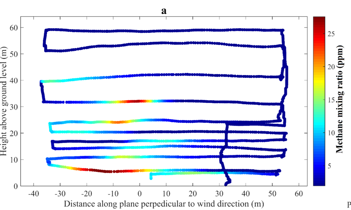
Methane detection survey at a closed landfill site
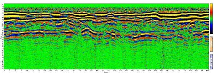
Magnetometer survey
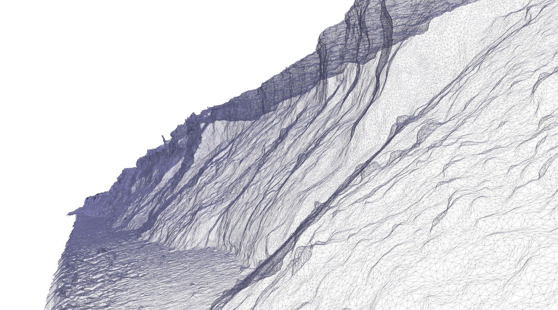
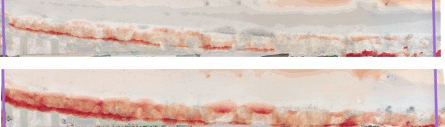
Lidar survey along a near vertical slumped face.
See Also