
BS16: Hydrology & Flood
We have and we are building the tools to support you in measuring your climate change impact. We wish to use best available leading edge science to provide robust data to ensure optimised actionable decisions.
Definition
Hydrology is the branch of science concerned with the properties of earth’s water and especially its movement in relation to land. Hydrology encompasses the occurrence, distribution, movement and properties of water and its relationship within the environment. This includes where there is an impact relating to humans, resources and infrastructure.
The study of hydrology is a large area of science covering many critical aspects of water and how this impacts our lives.
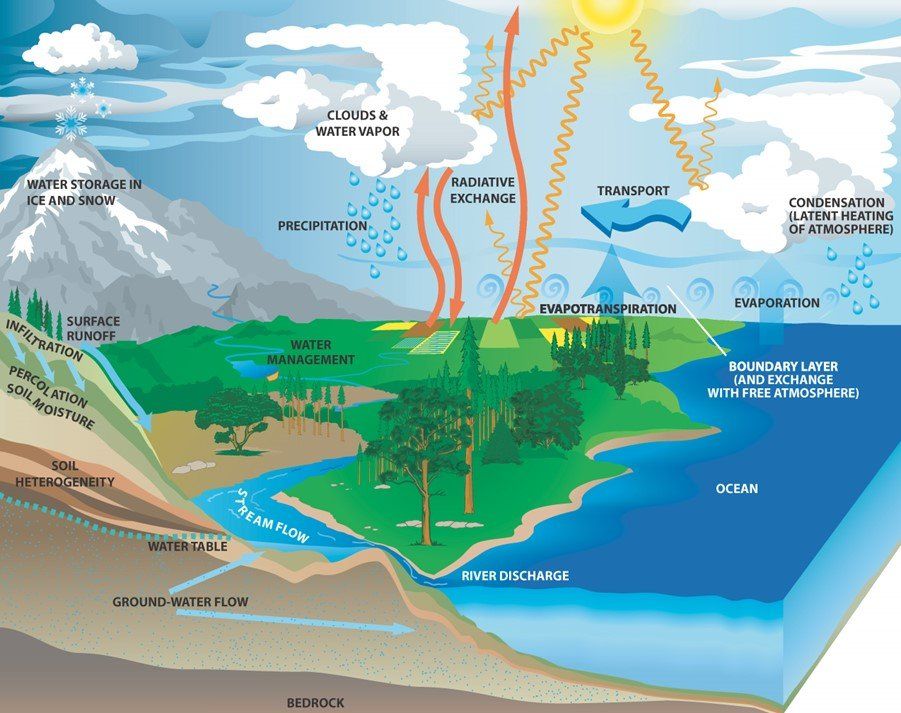
Hydrology Cycle Concept
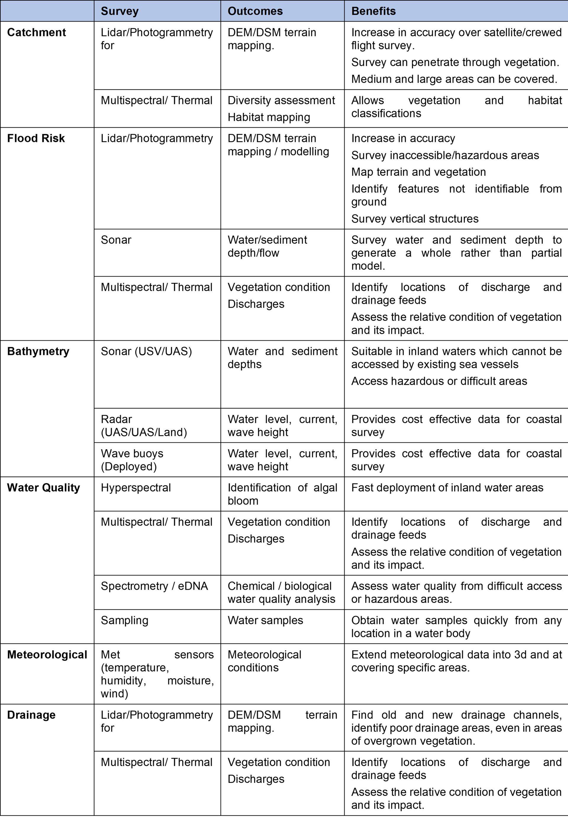
Typical Survey & Assessment
Surveys can include an assessment of the land and features relating to the catchment and its drainage, the nature and condition of the water course/ drains /coastal waters/ storage or the atmospheric exchanges.
Catchment
Catchments or sub-catchments are specific areas related to a water cycle and may cover large areas. These areas are identified, assessed and monitored by the environment agencies to support catchment or river basin management plans. These plans will include projects to address requirements within the Water Framework Directive as well as local flood planning. The plans will examine storage, quality, drainage, flooding, biodiversity and sustainability.
Flood
All UK local authorities have a mandatory requirement to produce a flood risk management plan. The objective is to determine flood hazards and risks, develop objectives to manage the risk and to implement a plan with timescales to implement measures to reduce or mitigate risk.
The management plans will be based on an assessment of rivers and drainage within a catchment to determine the flood risks. The baseline data is typically obtained from satellite and fixed wing aerial surveys and derived topographical terrain maps. Modelling will typically involve examining rainfall, gradient, water flow and key infrastructure that may restrict flow as well as predictions on change in respect to climate change.
Flood management plans will be updated on a regular basis to take account of changes in drainage, development and new predictions on future weather conditions/ events. More detailed terrain and conditioning surveys will be undertaken for higher risk areas which are subject to proposed flood mitigation measures to support appropriate decision making on options available and specification requirements for natural or man-made measures.
Bathymetry
Bathymetry is the measure of the depth or water (and soft sediments) within a river, lake, reservoir, coastal area or sea. It is often extended to include the examination of feature such as currents, flows and waves. The depth of water and the changes in depth are important factors in assessing the water catchments, water cycle, flood risk and erosion.
Water Quality
The quality of water within a catchment, river or coastal environment is important in understanding ecology/ biodiversity and pollution impacts (industrial, farming, waste water). Environmental agencies will have a requirement to monitor the chemical and biological condition of main water bodies (reservoirs, rivers and coastal areas) and to determine quality classification. This is used to support environmental compliance as well as to support plans and measures for water quality improvements, in line with the Water Framework Directive.
There are many point and diffuse pollutant sources arising from run-off, drainage, industrial discharge and waste/foul water from farming, industry, water treatment and urban land. The responsibility to manage these rests with the environment agency, including the permitting and management of discharges from industry and waste water treatment. This in most cases places an obligation on the ‘polluter’ to monitor and assess their own emissions into the water environment.
The quality of the water is critical to habitat, ecosystems and human health.
Meteorological
The assessment of meteorological conditions, within a catchment area, is typically based on available data from the Met Office (which will cover areas where ground based measurement equipment is available). The data is used to support modelling of the water cycle and feeds into predictions for flood events and drainage.
Drainage Assessment
Drainage assessment is typically required for new development (e.g. houses) in order to support sustainable urban drainage systems (SUDS), a typical condition of planning. New development will normally increase surface water run-off from hard/permeable surfaces while reducing ground based water storage potential from soils. Without mitigation the increase in surface water run-off will increase stresses in existing drainage systems resulting in the possibility of increased probability or risk in flood events. Typical SUDS measures may include the addition of on site water storage in the form of underground storage or drainage channels/features (e.g. swale pond).
Drainage assessment is also important in agriculture and in rural land use systems to support the optimisation of crop growth. Farming based drainage systems will include field drainage and field ditches, normally used to prevent any water accumulation within fields. Drainage systems were also applied to peatland areas in attempts to drain the land and make it suitable for farming purposes. However, this also harms the peat systems which are considered an important carbon store to help mitigate climate change. In peatlands, restoration will involve the identification and removal of drainage networks to support conditions for the peatland to continue its growth in bog type conditions.
Drainage assessments are also required in a range of other application areas including forestry, sustainable/habitat restoration and hydropower management.
How can Drone Surveys Help
Traditional survey processes will use survey data obtained from satellite, fixed wing crewed flight and from ground/water level. The data from satellite and crewed flight will provide good coverage, but will have reduced accuracy. The data from ground/water will be of high quality, but will have limitations in terms of coverage as a consequence of access/hazards etc.
Drone platforms provide a solution that can increase the level of accuracy from aerial survey, while also allowing access to areas not previously accessible. This provides a solution to fill the survey ‘gap’ and provide an opportunity to provide richer, more accurate data with greater coverage.
Drones can also be mobilised quickly allowing the survey capture of flood events (extent, impact, depth, flow etc). Drones can also be used repeatedly to show the behaviour of a flood event, or the performance of a temporary, new or permanent flood mitigation feature.
Drone platforms with various sensors can be used together to provide a range of data outcomes that can significantly enhance hydrological assessment and providing a robust evidence base on which to inform decision making.
Survey Benefits, Issues and Considerations
The following re-iterates some of the common issues that surveyors are faced with and which should be considered when selecting an appropriate survey method.
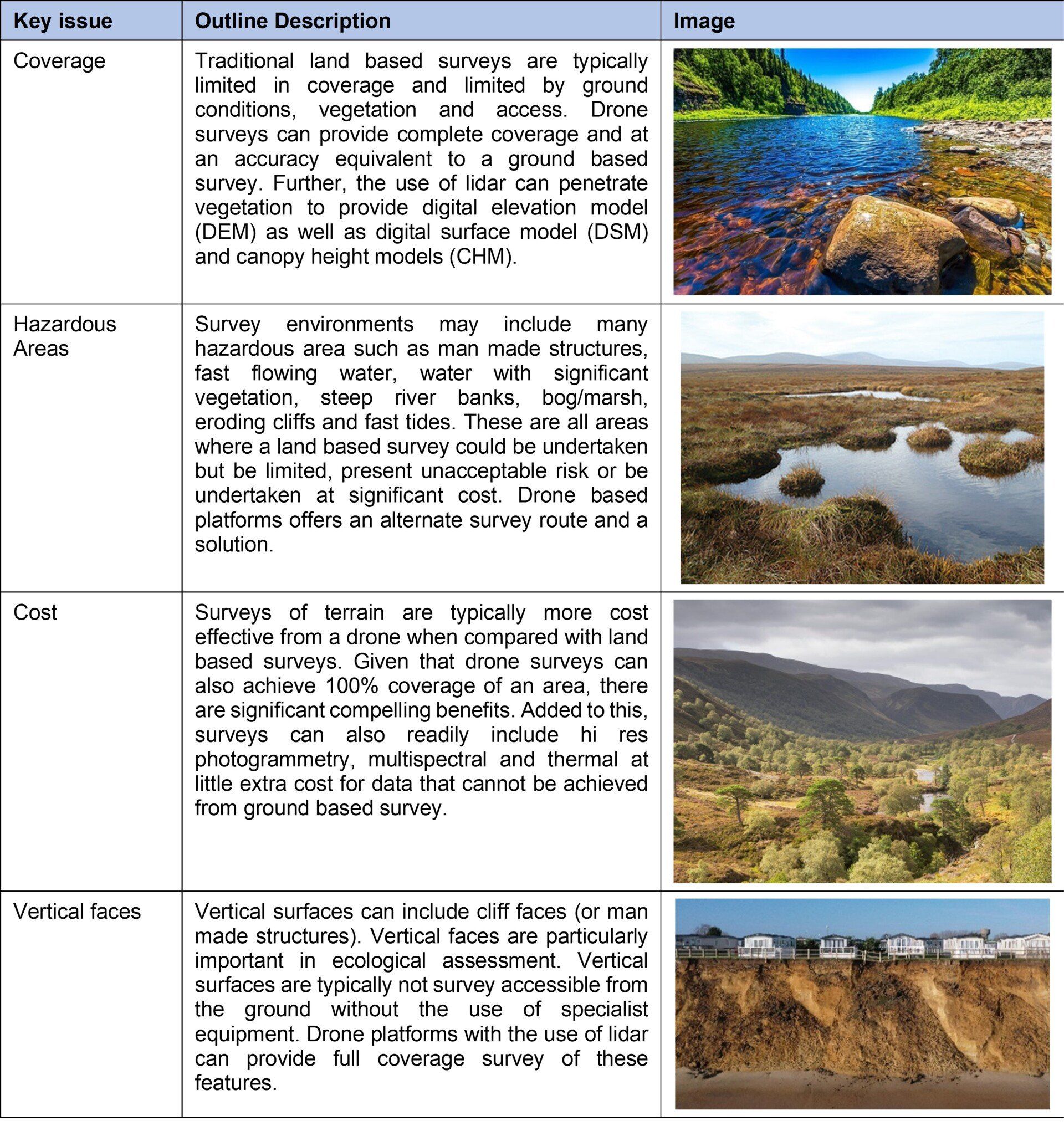
Drone based platforms are not infallible and have some limitations. These can include restricted flight areas and poor weather conditions. In many survey cases, it is useful to consider drones along with a number of survey tools from satellite data through to ground based survey.
Examples
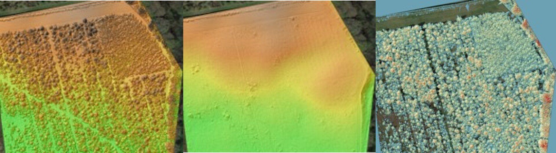
Example: Survey of a forest near Birmingham with DSM, DEM and CHM
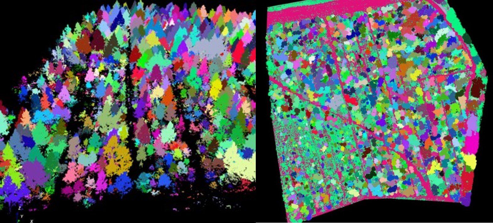
Example: Forest survey showing tree segmentations
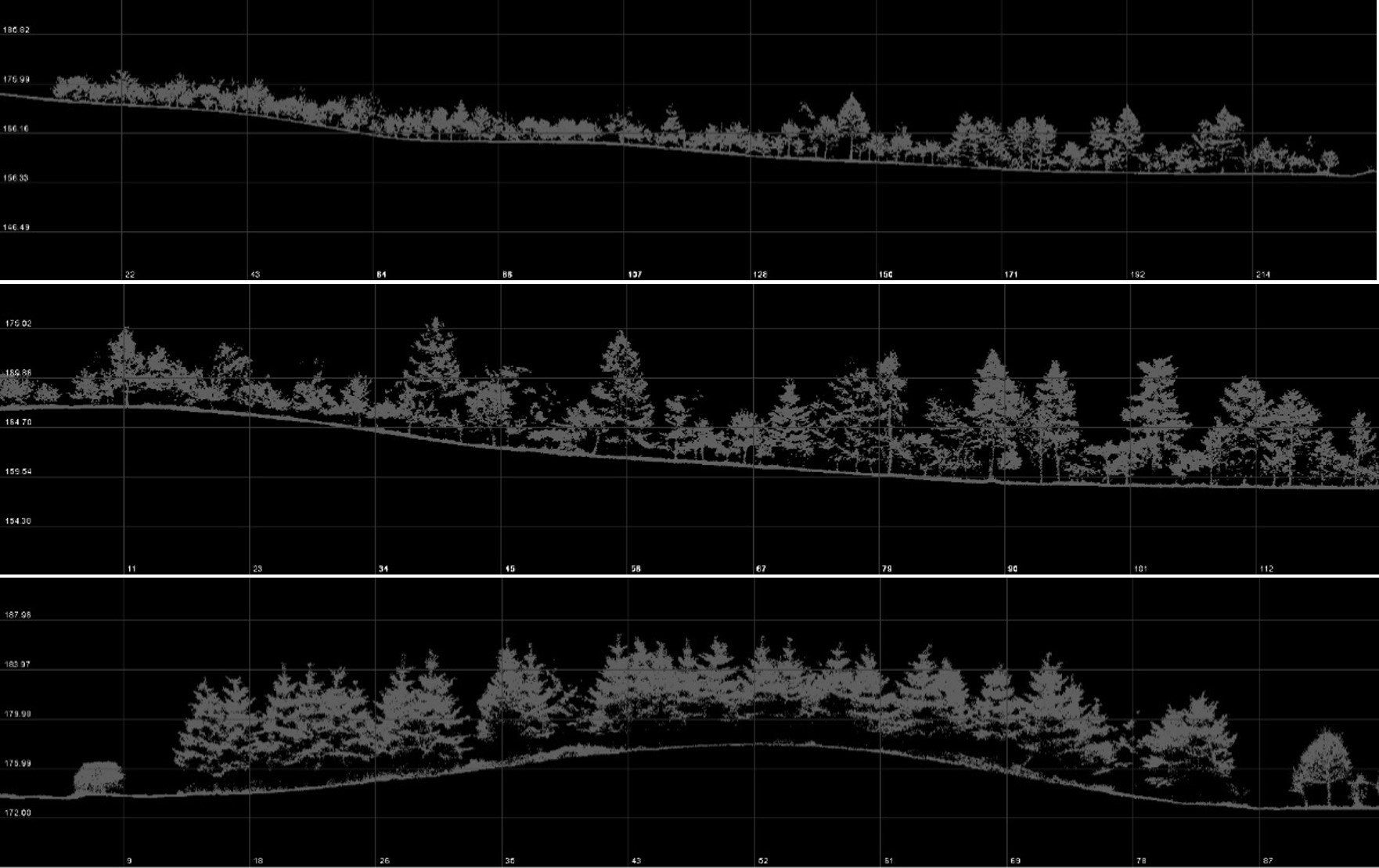
Example: Lidar surveys of forested areas, generated sections from various types of forested areas.
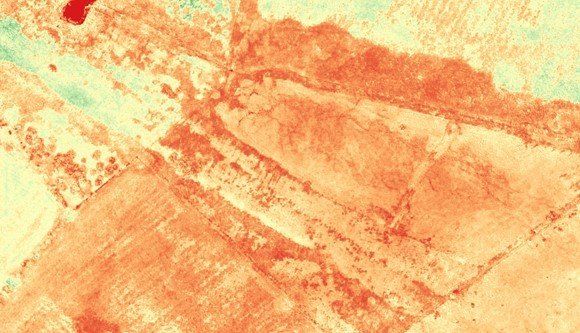
Example: Use of multispectral survey (OSAVI) to support drainage assessment at an agricultural site.
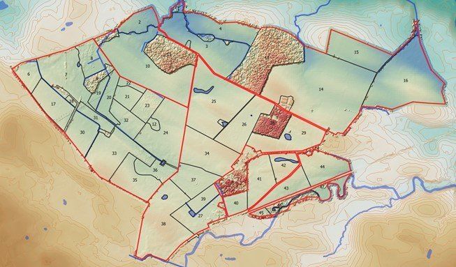
Example: Drainage and water feature mapping
See Also